
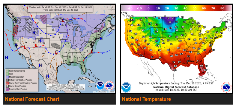
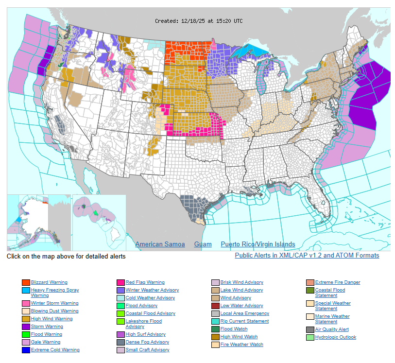
Strong winds and heavy snow will create dangerous travel conditions from the Northwest into the North-Central U.S. Heavy rain is also expected in parts of the Pacific Northwest, while mountain snow continues across the Northwest and Northern Rockies. Meanwhile, above-average temperatures will persist across much of the country through the end of the week, with possible record highs in the West and the Northeast/Mid-Atlantic.
A powerful storm system will move from the North-Central U.S. into the Northeast over the next couple of days. Wind gusts of 50–80 mph will impact much of the Northern and Central Plains and the Central Rockies today, leading to possible power outages, property damage, and very hazardous travel. High wind warnings remain in effect.
As this system strengthens, high winds combined with light to moderate snowfall will produce whiteout conditions across the Northern Plains through early evening. Visibility may drop rapidly due to blowing snow, making travel extremely dangerous. Blizzard warnings are in effect for parts of northeastern Montana, much of North Dakota, and portions of northwestern Minnesota.
As the storm moves east on Friday, gusty winds up to 60 mph, locally heavy rain, and lake-effect snow will impact the Northeast. These conditions may cause scattered power outages, downed trees, and travel delays. Wind advisories are in effect across much of the Northeast and the northern Mid-Atlantic.
In the Pacific Northwest, repeated storm systems will bring heavy coastal rain and significant mountain snow through the end of the week. Heavy rainfall is expected across southwestern Washington, western Oregon, and northwestern California, with an increased risk of flash flooding. Ongoing river and stream flooding may worsen, and landslides or debris flows are possible in steep or recently burned areas. Flood warnings remain in effect, with another round of heavy rain shifting south on Friday.
Above-average temperatures will continue across much of the West and East through the weekend. Several high temperature records may be tied or broken, especially on Friday. Warm, strong southerly winds ahead of the storm system will contribute to unusually warm conditions in the East, along with scattered showers and thunderstorms from the Mississippi Valley to the East Coast.
WYOMING
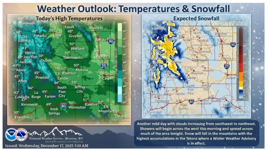
Less winds and cooler temperatures on tap for Thursday. The next storm system approaches later this afternoon as well with snow pushing in from the west and winds increasing once again overnight.
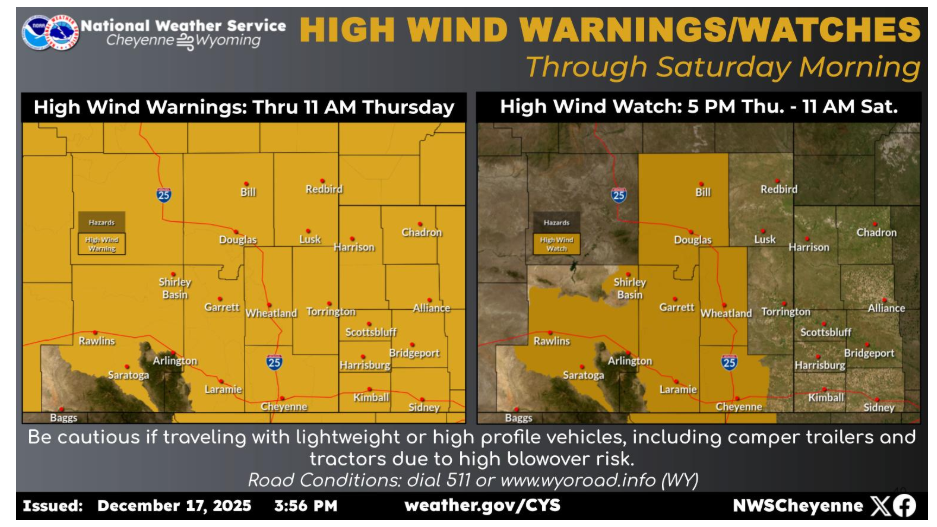
High Wind Warnings will continue across the region through 11 AM Thursday. A brief “lull” is expected late Thursday morning through the early evening hours. Winds pick up again Thursday evening, with gusts over 75 mph likely. Use extreme caution if traveling and pay attention to road signs!
NEBRASKA
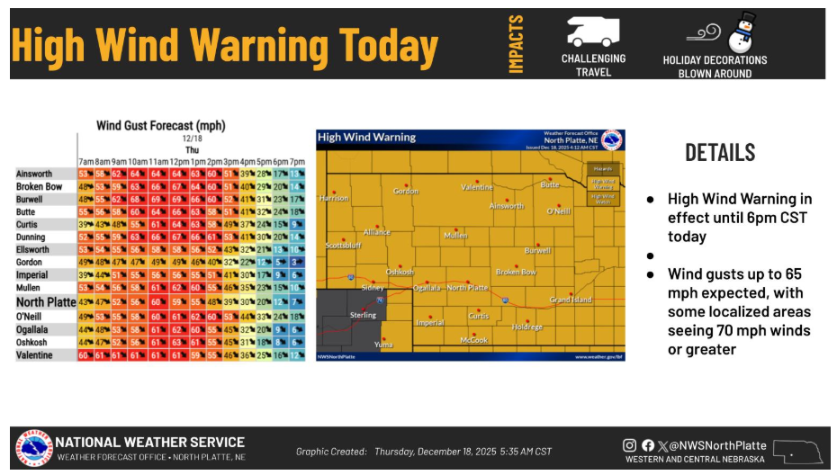
A High Wind Warning is in effect until 6pm CST today. Wind gusts up to 65 mph expected with some localized areas seeing 70 mph winds or greater. Impacts: Travel will be difficult, especially for high profile vehicles, loose objects will also blow around, including inflatable holiday decorations.
Have a nice and weekend!