
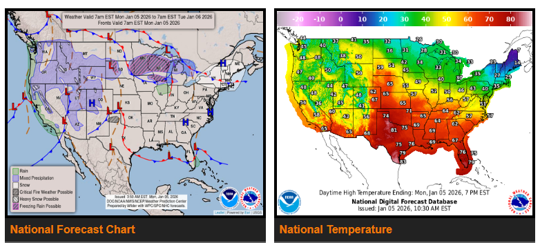
Moderate to heavy rain will continue across parts of California today, with an isolated risk of flash flooding. Another Pacific system will move into the Pacific Northwest on Tuesday, bringing additional heavy precipitation.
A broad upper-level trough will keep unsettled weather in place along the West Coast and much of the Interior West to start the week. Northern and central California will see continued moderate to heavy rainfall today as Pacific moisture moves inland, increasing the chance for isolated flash flooding. Heavy snow will persist in the northern Sierra and other higher elevations in far northern California but will gradually taper off this evening and end by Tuesday. Meanwhile, heavy mountain snow will continue across the northern and central Rockies and the eastern Great Basin.
By early Tuesday, another Pacific system will reach the Pacific Northwest, producing moderate rain at lower elevations and very heavy snow in the Cascades and Olympic Mountains, where totals could reach 2–3 feet. Snow will spread inland overnight into Tuesday, adding more accumulation across the northern Rockies.
East of the Rockies, an active pattern will bring multiple rounds of wintry weather from the Upper Midwest to New England over the next few days. Light snow showers are expected today across upstate New York and New England, with locally higher totals near Lake Ontario and in higher terrain. Beginning Monday evening, another system will bring a risk of impactful icing from central Minnesota into northwest Wisconsin, with ice accumulations up to 0.10–0.25 inches. This icing threat will shift east into the Great Lakes and Northeast on Tuesday, along with light snow for interior New England. Scattered rain showers are expected farther south from the Ohio Valley through the Appalachians.
Above-average temperatures will continue across much of the country and expand eastward this week. The warmest conditions will develop over the central and southern Plains on Monday, spreading toward the Mississippi Valley on Tuesday. Some areas may see temperatures 30–40 degrees above average, with a few record highs possible. Gusty, warm, and dry winds east of the Rockies will elevate wildfire risk across parts of the southern High Plains on Monday, including a Critical fire weather risk for the Texas Panhandle.
Colder air will linger across the Mid-Atlantic and New England early in the week, but gradual warming is expected by midweek. The West Coast will remain slightly below average, with highs mainly in the 40s and 50s in the Pacific Northwest and 50s and 60s in California.
WYOMING
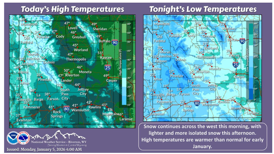
Snow continues across the west today, mainly for the mountains, though lighter snow is possible for lower elevations. Otherwise, temperatures remain warm for early January.
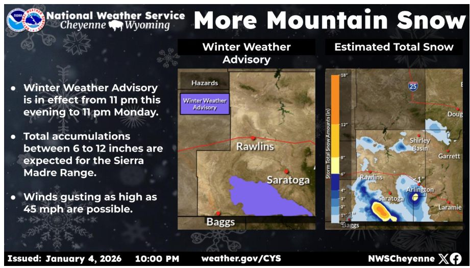
A winter weather advisory has been issued for the Sierra Madre Range beginning 11 pm this evening and expires at 11 pm Monday for 6 to 12 inches of snow. In addition, winds may gust up to 45 mph causing blowing snow.
Have a fantastic day.