
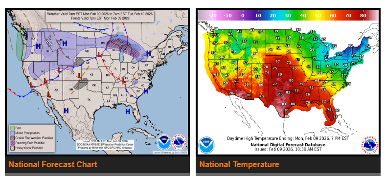
Lingering rain at lower elevations and snow in the mountains will continue Monday across the Pacific Northwest following a recent Pacific system. In the northern Rockies and adjacent High Plains, lower elevations may see a wintry mix while higher elevations receive moderate to locally heavy snowfall. On Tuesday, the focus shifts south to California as another Pacific system moves in. This system will bring moderate rain to coastal and lower elevations, with heavy snow expected in the Sierra Nevada. Precipitation may continue into Wednesday and gradually spread east into the Great Basin and parts of the central Rockies.
Meanwhile, a clipper system moving along the U.S.–Canadian border will bring light snow and possible freezing rain to portions of the Upper Great Lakes on Monday. As it moves east on Tuesday, moderate snow is expected in parts of Upstate New York and central New England. Ahead of a cold front, showers and thunderstorms may develop Tuesday across the Tennessee Valley, Mid-South, far West Texas, and portions of the Southwest.
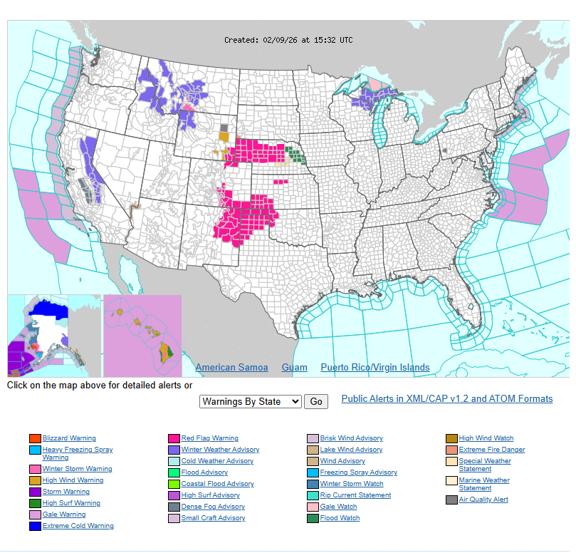
Warmer-than-average temperatures will continue across much of the central and western United States. Highs in the central Plains will reach the 60s and 70s, which is 35 to 40 degrees above normal for early February, with some record highs possible. The southern Plains, Southwest, and southern California will see highs in the 70s and 80s. Gusty winds combined with low humidity have created a critical fire weather risk across parts of the central and southern High Plains. The Interior West will see highs in the 40s and 50s, while the Pacific Northwest and California range from the 50s to 60s.
In the eastern United States, temperatures will gradually moderate after recent cold conditions. By Tuesday, highs will range from the 20s and 30s in New England, 30s and 40s across the Great Lakes and northern Mid-Atlantic, 40s and 50s from the Ohio Valley to the southern Mid-Atlantic, and 60s to 70s across the Lower Mississippi Valley and Southeast.
WYOMING
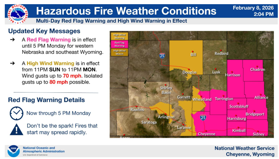
The High Wind Warning has been expanded to include the I-80 Summit through 11pm Monday. The Foothills remain in a High Wind Watch through 11pm Monday. The Red Flag Warning remains in effect through 5pm Monday with the worst conditions expected Monday afternoon along I-80 east of the Laramie Range.
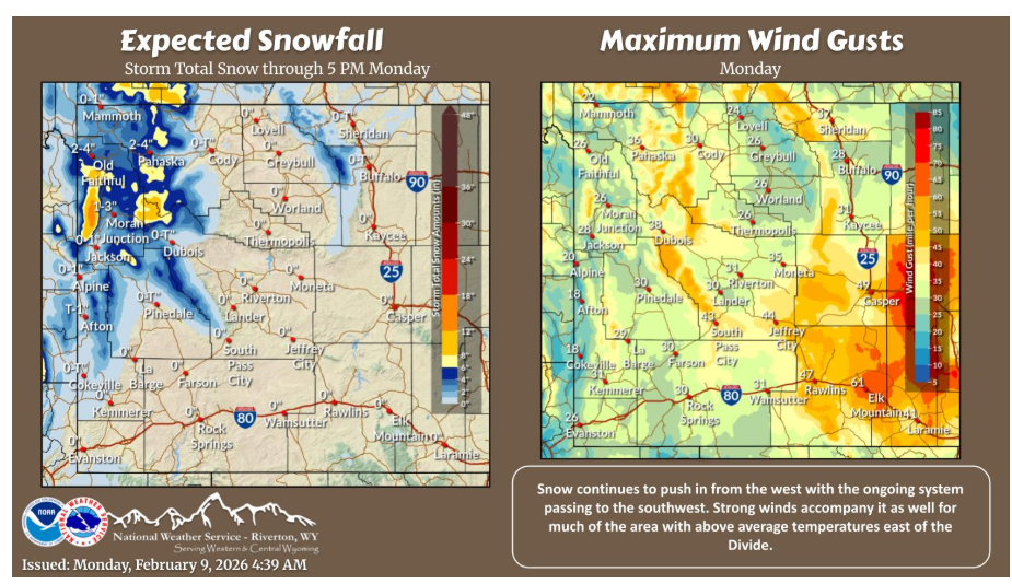
Changing weather pattern to start the work week as snow pushes in from the west. Windy conditions across much of the area today with above average temperatures east of the Divide, albeit not as much today. Cooler tomorrow with even more precipitation chances to come.
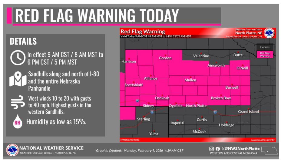
A Red Flag Warning is in effect Today from 9 AM CST / 8 AM MST to 6 PM CST / 5 PM MST across the Sandhills, along and north of I-80, and the entire Nebraska Panhandle. Unseasonably warm temperatures in the low to mid 70s will combine with gusty west winds and afternoon humidity as low as 15 percent will create critical fire weather conditions. The strongest winds will be across the western Sandhills, where west wind of 20 to 30 mph with gusts to 40 mph. Any fire that starts could spread rapidly and be difficult to control.
Have a fantastic day.