
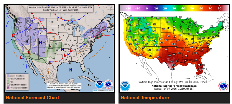
A strong storm system will bring snow to the Four Corners region and widespread showers and thunderstorms from the Plains into the Midwest and Mississippi Valley on Thursday. By Friday, the threat shifts to the Lower Mississippi and Tennessee Valleys, where heavy rain could lead to flash flooding and severe weather.
The system begins as an upper-level disturbance moving south along the West Coast, then east into the Southwest. Moisture ahead of it will bring rain and thunderstorms to the Desert Southwest, followed by mountain snow across the Four Corners region Wednesday night into Thursday. Moderate to locally heavy snowfall is expected, especially overnight. Several inches of snow are possible from southern Colorado into northeastern New Mexico, with lighter accumulations extending into southwestern Kansas and the Oklahoma Panhandle.
As the system moves into the Plains, a developing low-pressure system will trigger showers and thunderstorms from the central and southern Plains into the Midwest and Mississippi Valley on Thursday. While most areas will see modest rainfall, much heavier rain is expected Friday farther south, increasing the risk for flash flooding and severe storms. Some light wintry precipitation is possible from Nebraska into the Upper Midwest, though little accumulation is expected.
Meanwhile, very heavy snow continues in the Pacific Northwest. The Cascades and Olympics could see an additional 1–2 feet of snow, bringing storm totals to 3–4 feet. Snow will also impact the northern and central Rockies, the Great Basin, and parts of northern California and the Sierra. Lower elevations of the Pacific Northwest will see moderate rainfall, while precipitation gradually tapers off by Friday. Light snow and icing may linger today in parts of New England.
Temperatures will remain well above average across much of the central and eastern U.S. this week. Some areas may run 25–35 degrees above normal, with potential record highs shifting east from the Plains on Wednesday into the Midwest on Thursday. In contrast, colder air will spread across the western U.S. behind multiple cold fronts, bringing below-average temperatures by mid to late week.
WYOMING
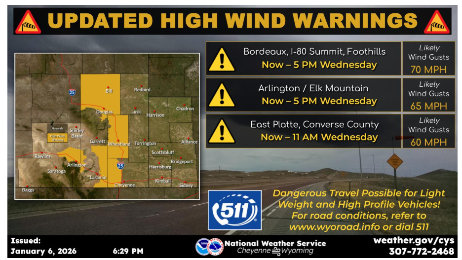
Here’s an update on the High Wind Warnings in effect. Most go through 5 PM Wednesday, but East Platte County and Converse County will end at 11 AM Wednesday. Gusts between 60 and 70 mph likely throughout the zones. Use caution if traveling with light weight or high-profile vehicles.
Have a fantastic day.