
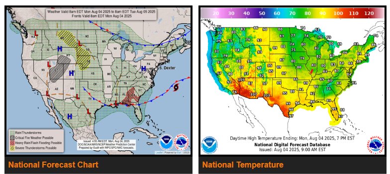
A front extending from the Southeast westward along the Gulf Coast to the Southern Plains will remain quasi-stationary through Wednesday. The front will trigger showers and thunderstorms, accompanied by heavy rain, over parts of the Southeast.
Additionally, upper-level energy and a steady source of moisture will produce showers and severe thunderstorms over parts of the Northern/Central High Plains. Therefore, the SPC has issued a Slight Risk (level 2/5) of severe thunderstorms over parts of the Northern/Central High Plains through Tuesday morning.
Further, upper-level energy will produce showers and thunderstorms over parts of the Pacific Northwest, Northern Intermountain Region, and Southern Plains from the late afternoon into the late evening on Monday.
On Tuesday, tropical moisture over the Southeast, along with a lingering boundary, will produce showers and thunderstorms with heavy rain over parts of the Southeast/southern Mid-Atlantic.
In addition, a strong upper-level impulse will produce showers and severe thunderstorms over parts of the Northern Plains. Therefore, the SPC has issued a Slight Risk (level 2/5) of severe thunderstorms over parts of the Northern Plains Tuesday through Wednesday morning.
Moreover, showers and thunderstorms are expected to develop from the Upper Mississippi Valley/Great Lakes southward to the Gulf Coast and parts of the Northeast on Tuesday.
Furthermore, an intensifying upper-level high over the Southwest will produce upward-trending temperatures across the Desert Southwest. High temperatures are expected to reach the mid-110s by Tuesday. The most significant heat is forecast to focus over central and southern Arizona with widespread Major to Extreme Heat Risk.
WYOMING
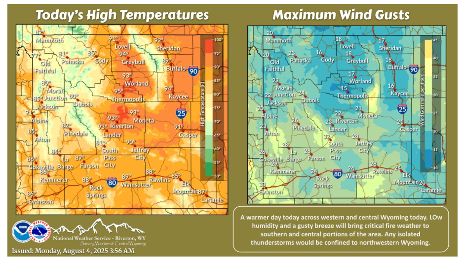
Hot temperatures returning to the area this afternoon. A gusty breeze will develop across southern Wyoming and bring critical fire weather. Any thunderstorms will be confined to northwestern Wyoming.
NEBRASKA
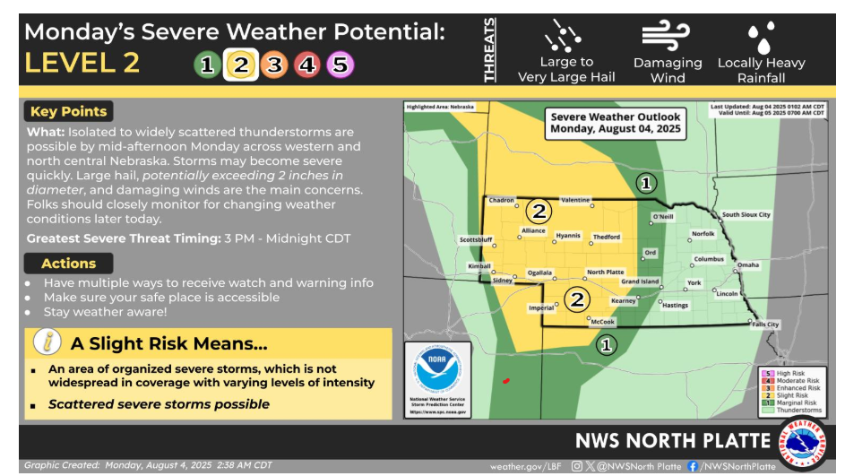
A Level 2 (Slight Risk) of severe storms is in place for much of western and north-central Nebraska on Monday. Storms may develop by mid-afternoon and continue through midnight. The main concerns are large hail (possibly over 2 inches in diameter) and damaging winds. Be prepared: • Greatest threat timing: 3 PM to midnight CDT • Make sure you have multiple ways to get warnings • Know your safe place and stay weather aware A Level 2 risk means scattered severe storms are possible. Stay tuned for updates as conditions evolve.
Have a fantastic day!