
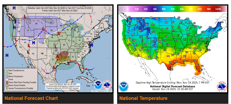
Flash flooding and severe weather will move through the Arklatex region today, then shift into the Tennessee Valley and interior Deep South/Southeast on Tuesday.
A long stretch of snow is expected from the Canadian border of Montana today into tonight, spreading across the northern Plains Tuesday and into the upper Great Lakes Tuesday night into Wednesday morning.
Temperatures will stay well above average across most of the central and eastern U.S., while the Pacific Northwest to the Great Plains turns blustery and colder.
A developing low over the south-central Plains will bring heavy rain and severe weather to the Mid-South through the next couple of days. Moisture from the Gulf will fuel strong thunderstorms and heavy downpours across the Arklatex as a warm front moves north and a cold front arrives from the west. Recently soaked areas in the Texas Hill Country face the greatest flash-flood risk.
The SPC has a Slight Risk (level 2/5) for severe storms from eastern Texas through northern Louisiana, southern Arkansas, and into western Mississippi. On Tuesday, the system moves east with heavy showers and storms from the Deep South into the interior Southeast, but with lower severe and flooding chances. By Tuesday night, the low will track toward the lower Great Lakes, spreading rain across the Ohio Valley, Mid-Atlantic, and into New England. Scattered thunderstorms may form along the East Coast as the cold front approaches.
Another frontal system entering the Pacific Northwest will bring widespread precipitation this morning, followed by heavy high-elevation snow and strong winds across the northern Rockies. An upper trough will strengthen and push a fast-moving clipper system through the northern Plains Monday night and Tuesday, producing 3–6 inches of snow from Montana through the northern Plains and into the upper Great Lakes Tuesday night into Wednesday. High wind threats increase Tuesday across the northern Plains and spread into the upper Midwest Wednesday morning.
A second Pacific system will reach the Northwest by late Tuesday, bringing another round of low-elevation rain and mountain snow.
Much of the eastern and central U.S. will remain warmer than average, with highs in the 80s along the Gulf Coast, 60s/70s from the southern Plains to the Southeast, 50s/60s from the central Plains to the Ohio Valley, and 40s/50s across the Upper Midwest/Great Lakes. New England will see highs in the 30s/40s. As a cold front moves east, temperatures will fall into the 30s for many areas.
Across the West, highs will remain near normal—60s/70s in southern California and the Desert Southwest, 50s/60s along the West Coast, and 40s/50s across the Interior West.
WYOMING
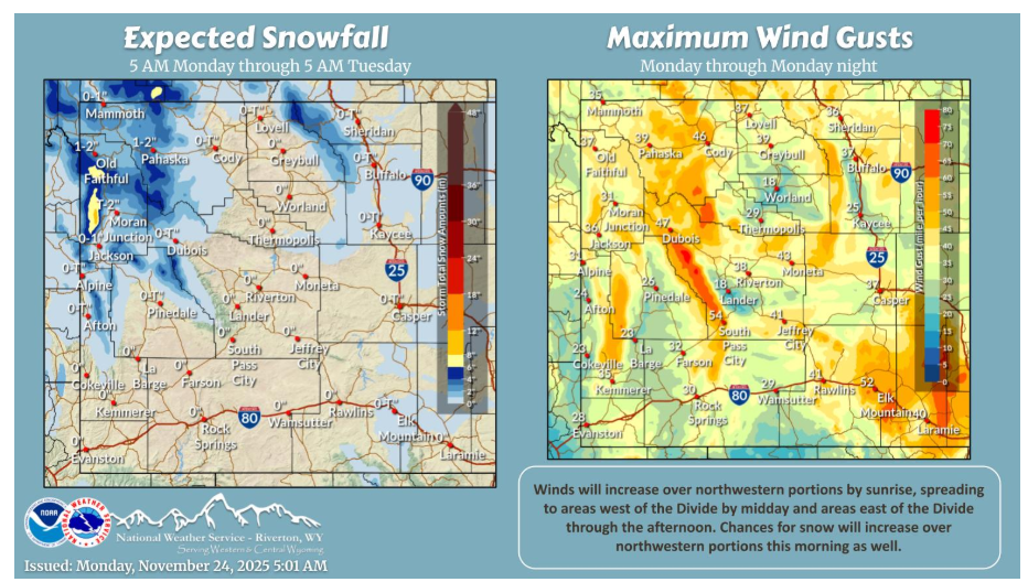
A strong cold front will approach the area today, moving thru late this afternoon into tonight. Winds, along with chances for snow, will increase over northwestern portions by sunrise. Winds will increase across the rest of the area through the day and continue tonight.
NEBRASKA
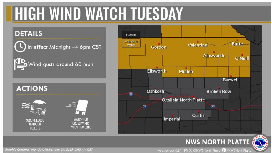
A High Wind Watch has been issued for northern Nebraska on Tuesday, with the strongest winds expected from Midnight through 6 PM CST. Wind gusts may reach around 60 mph, which could easily blow around unsecured outdoor items and make travel—especially for high-profile vehicles—more difficult. Now is a good time to bring in or tie down anything that could become airborne and plan for slower, more cautious driving if you’ll be on the road.
Have a fantastic day.